Of the natural obstacles which impede the movement of people through the landscape and the construction of transport and communications networks, streams and rivers are by far the most numerous. The challenge of crossing these watercourses, either as part of the passage from one settlement to another or in order to connect a settlement on either side of the river has existed since prehistory and although technology has developed through the centuries, the means of traversing rivers have remained the same.
The simplest form of river crossing and that for which there is the earliest evidence are fords. A ford is shallow point at which a river or stream can be crossed by wading, on horseback or in a vehicle. Most often, ford’s are naturally occurring rather than man made and as such can be said to influence the choice of location of many of England’s towns and villages. The suffix ‘ford’ appears in the names of a great number of English settlements, of which Oxford (the place where oxen crossed the river) is perhaps the most well know. However many far smaller settlements appear to have developed as a result of their proximity to a point in which a river was naturally fordable. One such example is Codford in West Wiltshire, which takes its name from one of two Anglo-Saxon fords (Coda’s ford and Oda’s ford) which crossed the river Wylye and formed part of a wider network of communications with neighbouring estate centres.
Although the cheapest and simplest form of river crossing, fords are unreliable and can become impassable when a river is in spate, during times of flood or even after a period of heavy rain. Fords on estuarine rivers were also subject to the tides and thus also regularly impassable. Although largely replaced by bridges in the later medieval period, fords still exist in great number in rural areas such as Exmoor, as the means of crossing small water courses.
Larger, deeper and faster flowing rivers are less likely to have a natural point at which they can be safely and reliably forded and the next simplest solution was to operate a ferry. The river Wear at Sunderland for example, divided the two ancient parishes of Monkwearmouth and Bishopwearmouth and although the river mouth could be forded at low tide until at least the 14th century, ferries provided the most reliable way of crossing the river. A ferry is believed to have existed at Sunderland as early as the 7th century when it was used by the monks of St Peter’s monastery and the ferry upriver at Hylton was part of a major transport network, carrying the old high road north to Newcastle.
River ferries, restricted in the volume of people and goods they can transport, have been almost totally replaced by bridges and tunnels, (although a ferry service still exists in London, connecting Woolwich, south of the Thames with North Woolwich), evidence of ferry crossings can still be found along the banks of rivers in major cities in the form of stairs and ferry landings.
The most reliable, but most expensive means of crossing over a river or valley is to build a bridge. Evidence for early timber bridges is extremely scarce, although it has been suggested that the prehistoric timber palisade platform excavated at Flag Fen, near Peterborough, may have been an early form of bridge, used to cross the waterlogged fens. An ancient form of bridge, unique to the upland regions of England and Wales, are Clapper Bridges. Formed by large, flat slabs of stone supported on stone piers, these bridges, such as Tarr Steps on Exmoor, are often thought to be prehistoric in date, but most were erected in the medieval period.
The traditional method of constructing bridges (as we would recognise them today) dates back to the ancient world and involved building an arch, or a series of arches from wedge shaped pieces of stone (voussoirs), around a wooden centring, which was removed once the keystone of the arch was put in the place. The arches were built onto piers or abutments on either side, allowing a relatively wide river to be crossed using a number of arches or spans. The 14th century Bridge across the River Medway at Aylesford in Kent is a good example of this traditional method of bridge construction.
Traditional masonry bridges could often impede river traffic and therefore not all rivers could be bridged and ferries continued in use. However in 1781, the world’s first cast iron arch bridge was opened across the Severn Gorge near Coalbrookdale, beginning a new chapter in bridge construction. Having proved it was possible to cross a wide river with a single iron arch; other bridges of that type were constructed around England such as the Wearmouth Bridge in Sunderland which opened in 1796.
Following the technological breakthroughs of the late 18th century, bridge building developed rapidly throughout the 19th century and many of the great engineers of the day became heavily involved with bridge construction. Many of these great works survive in use today such as Thomas Telford and Robert Stephenson’s bridges over the Menai Straight, opened in 1826 and 1850 respectively and I.K Brunel’s Royal Albert Bridge over the river Tamar (1859) and the iconic Clifton suspension bridge, which was completed in 1864, five years after Brunel’s death.
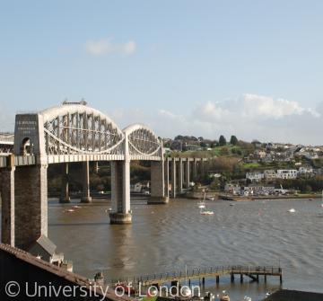 I.K Brunel's Royal Albert Bridge over the river Tamar links Devon with Cornwall and was completed in 1859


