The Gunfleet Estuary and Holland Haven
The Gunfleet was the name of the large estuary fed by the Holland River or brook, which formerly ran into the sea between Frinton and Little Holland. The name is probably Anglo-Saxon in origin, as the second element ‘fleet’ is derived from the Old English word fleot meaning ‘stream’ or ‘creek’. A similar well known example is the River Fleet in London, a tributary of the River Thames which was fed by streams on Hampstead Heath and which used to have a tidal inlet and docks at its lower end. The origin of the first element of the name ‘Gun’ is currently unknown, but it possibly derived from an Anglo-Saxon personal name, so the meaning of the whole name could be something like ‘Gunna’s creek’. An alternative suggestion that has been made is that the first part of the name could be a corruption from the Count of Guisnes who possessed the manor of Little Holland in 1210.
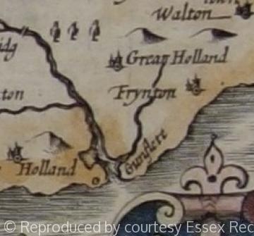
However, the name was not recorded until 1320 when a vessel was shipwrecked on ‘Gunfletsond’, that is to say the Gunfleet Sands. It seems probable that a name originally applying to the estuary was appended to the sandbank that lay directly off the coast and opposite the estuary’s inlet. A map of 1584 in the British Library marks both the ‘Gonflet haven’ (the estuary) and the ‘ye gonflit’ (the sandbank). Other maps from that period, such as maps of Essex by Norden (1594) and Speed (1610) show the Gunfleet as a large, unreclaimed, estuary that was open to the sea at its southern end. The use of the name ‘haven’ would seem to imply the use of the estuary for trade, and the ‘Ganflete’ was also named as a port between Walton and St Osyth in Holinshed’s Chronicles (1586). The substantial marshlands along the estuary were also used by the inhabitants of surrounding parishes like Great and Little Holland as grazing for their sheep.
In 1542 ‘the level of Gunflete haven’ was recorded, perhaps indicating that estuary’s marshland later known as Holland Levels had started to be reclaimed. Although the estuary continued to be marked on coastal maps and sea charts for a long time, it was becoming blocked perhaps by the effects of coastal erosion and long-shore drift. In 1677 a whale was stranded in the narrows at what was probably the entrance to the Gunfleet estuary then described as a ‘creek’. Probably soon afterwards it was decided to reclaim the estuary by constructing a sea wall across its mouth, with a sluice provided to allow the river water to drain away to sea. The intention was to prevent salt water entering the marshes along the Holland River, and thus to improve their agricultural potential and value. It is not known when the first wall was built, but in 1703 a survey was taken of ‘ye Levell or Flatts being several pieces or parcells of land endamaged by a breach at, or near Gunfleet Haven’.
The records of the Tendring Levels Commissioners, a type of local government body charged with flood defence, survive from 1727 and show how they maintained the drained marshlands of the level, the sea wall and the sluice through which the Holland River then emptied into the open sea. By the 1760s the area was sufficiently drained to allow a new road link to cross the former estuary from Holland on Sea to Great Holland, although the extensive tracts of land were still liable to flood as shown by the marshes depicted on the Chapman and André map of 1777 and the one inch Ordnance Survey map (1838 edition). The Commissioners continued to be responsible for maintaining the sea wall and the Levels until the 1930s, and their maps reveal the outline of the old estuary through the land that had to pay rates to maintain the sea defences.
Sources: P.H. Reaney, The Place-Names of Essex (1935), pp.13–17. K. Walker, various notes. Calendar of Close Rolls, Edw. II, A.D. 1318–23 (HMSO, 1895), p.249. Holinshed, An Historicall Description of the Iland of Britaine (1586), Book I, Chapter XVII: Of such ports and creeks as our sea-faring men doo note for their benefit upon the coasts of England. British Library, Ms cott. Aug. I.1, f. 44 (map, 1584) J. Norden, Speculi Britanniae Pars (1594), ed. H. Ellis (Camden Society, London, 1840), map. J. Speed, Map of Essex (1610) J. Chapman and P. André, A Map of Essex (1777). Ordnance Survey map, 1” to 1 Mile (1838) Essex Record Office, D/DHw E14, ‘A true Survey of ye Levell or Flatts’, 1703. ERO, D/ST 1 to 6, Tendring Levels Commissioners, minute books, 1727–1932 ERO, D/ST 17 to 20, Tendring Levels Commissioners, maps, 1783 ERO, T/M 565/1, 2, Tendring Levels Commissioners, maps c.1901–25.
Content derived from research undertaken as part of the Victoria County History project
Content derived from research undertaken as part of the Victoria County History project
Content derived from research undertaken as part of the Victoria County History project


