Fields, Meadows and Boundaries
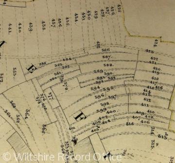 Codford St Mary’s open fields still existed when this tithe map was drawn in 1840.
Over much of the country at some point prior to the 19th century some form of field system operated. This was a communal system in which the farmers shared risk in order to maximise land use, and at the same time to allow land to go out of cultivation (fallow) every two to three years in order to give it time to recover fertility before further crops were sown. The classic system was the Midland open field three course, but two, four and other multiple systems were known.
Normally land spent one or two years under crops and then lay fallow for a third year before cropping resumed. Some areas of land were too low lying, and damp, for cropping, and they were sometimes held in permanent meadow (where they were only grazed after the Spring grass crop was ready to be eaten off) or permanent pasture, land where animals were grazed through the year. Boundaries had to be maintained, especially in the open field system, and this was often done by annual field days when the manor court jury would walk the fields and measure the roadways for evidence of farmers ploughing too far – a practice still maintained at Laxton, Nottinghamshire. The system depended on co-operation (not co-operatives as such) and farmers needed to work together, hence the importance of gatherings of the manor court.


