Settlement and Topography
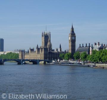 London, City of Westminster, from the River Thames. Westminster is just one of the settlements which coalesced to form the capital city we know today
Over the last three millennia the landscape of England has been shaped by settlers. They have created places to live and have sustained themselves by exploiting the land and its resources. The description of the natural land forms and physical patterns imprinted on them by human activity is known as topography (from the Greek for place 'topos' and writing 'graphia'). England has a long tradition of topographical writing. It became firmly established in the 16th century when antiquarians began to describe systematically their physical surroundings and record relics from earlier centuries, including inscriptions and the content of documents. The tradition has survived, one strand of it developing into the study of Local History in which documents have been used, together with evidence from archaeological sites and buildings, to chart the development of particular places and communities. The most comprehensive collection of information from those sources has been carried out since 1899 by the historians of the Victoria County History. Their publications - 'big red books' - provide a foundation for anyone wishing to explore the history of their community and the topography of their locality.


