Feeding the Capital
The Gunfleet estuary was formerly known as the Gunfleet Haven, the word haven meaning a port or harbour for boats. This name is used in customs documents and surveys from the reign of Elizabeth I, revealing the role of Gunfleet Haven as a port at that time.
In the past, goods could be easily transported between Essex, London and the rest of the country using the waterways and sea. Quays, wharves and landing places along the Holland Brook were easily accessible along tracks leading directly from surrounding farmland. Beaumont Quay, accessible from Hamford Water, is a surviving example of a small local quay and can be used as indication of what the Gunfleet estuary may have been like.
Corn and hay grown in nearby fields, and cheese that was produced in local dairies called “wicks”, was exported to London from these small quays. Sheep kept on the marshland surrounding the estuary were kept for wool, meat, and also for their milk which was used to make these large Essex ‘Wicks’ cheeses which were exported as a cheap foodstuff to London. Jaywick is a good example locally of a place with wick in its name.
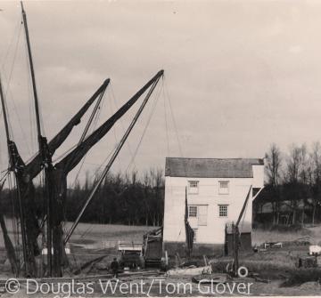
Corn might also be taken from the farms to nearby mills for grinding into flour to make bread. A good number of these local mills were tide mills located on the coastline, especially around the Colne, Hamford Water and the Stour. Tide mills rely on the timing and strength of the tides so would need to be worked at night when necessary and in conjunction with a windmill, as at Thorrington and Walton-on-the-Naze.
Although much of the flour produced would be for local consumption, tide mills had easy access to sea communications and probably all of them had a wharf or quay adjacent which could be used for bringing in corn and exporting flour for use elsewhere.
Essex County Council own and maintain Thorrington Tide Mill which is restored and open to the public on certain days. It is one of the few tide mills in Great Britain that is still operational and is of national significance in explaining how the natural resources were harnessed to produce power in the past.
Barges that sailed to London with goods did not return empty. The two-way traffic between Essex and the capital is described in a 1727 survey of Beaumont Hall. The survey noted that there were two "very convenient landing places for bringing chalk rubbish from Kent and carrying of corn or any other thing off to London". Chalk was brought as a soil improver from quarries along the Thames estuary in both Essex and Kent, along with another soil improver, horse manure and human 'night soil'. Barges might also bring cargoes of building materials, such as stone, flint or bricks.
Farmers in Essex wanted to apply chalk to the land to correct high levels of acidity in the soil and improve crop yields. Chalk could simply be spread on the land but was more efficient when used to create ‘quicklime’. There was a further demand for lime for use in lime mortars in the building industry in the 19th century.
Producing lime from chalk required a kiln which would have been a natural addition to the facilities alongside many of the small Essex quays, wharves and landing places. At Beaumont Quay there is a fairly rare East Anglian (mixed-feed) design kiln. It is a circular red brick building within an earthen mound, and is approximately 2.5 metres high and 13 metres in diameter. The kiln was probably in continuous use and the quay would have large heaps of chalk and coal around ready for processing.
The heyday of Beaumont Quay was the mid and late 19th century when improvements in agricultural production and yields persuaded the owners to invest in creating a more efficient quay. In 1831 stone from the demolition of London Bridge was used to build a new quay and a deeper channel or canal was cut. Along with a basin that enabled boats to turn these improvements meant that the quay was suitable for use by larger vessels.
You can explore Essex feeding the capital using the suggested activities and assets below.
Put Holland Haven in a regional context
Use Possible landing places on the Gunfleet Estuary, image of barges at Thorrington Tide Mill (1929), Beaumont Quay surveyed in 1727, lime kiln at Beaumont Quay (1), Thorrington Tide Mill in 1777
Design your own way to illustrate the movement of resources between Essex and London. Perhaps this could be a circular flow chart or river display. Make sure that your chosen method describes what is sent to London, from where and why, and what is brought to Essex, from where and why. Can you demonstrate how the resources coming to Essex contribute to local activity and future exports?
Renewable energy in Holland Haven
Use image of barges at Thorrington Tide Mill (1929), Diagram of typical undershot of Tide Mill, Mill stones after restoration, Thorrington Tide Mill in 1777, Possible landing places on the Gunfleet estuary
Make a list of as many power sources as you can (include renewables such as wind and water as well as non-renewables such as coal). Discuss or group these by how these are used today, for example, we use petrol in cars, create electricity from fossil fuels etc) and consider the advantages and disadvantages of each.
Use the sources for Thorrington Mill, powered by the tides, to demonstrate how renewable sources were used in the past to provide power that is now produced in other ways. What are the advantages and limitations of these sources? How did the millers at Thorrington overcome any limitations? Design, make and test your own model mills, either a windmill or watermill.
Extend this to consider the wider use of local natural resources such as rivers and the coastline as a method of transport and communication network. How is similar or different to today? You could use the sources to make your own model windmill.
A working Quay
Use plan of Beaumont Quay, The barge Rose at Beaumont Quay (1), lime kiln at Beaumont Quay (1 & 2)
Imagine you are working at Beaumont Quay in the 19th century. Use the images and plan to think about what work and activity happened at the quay at its peak. You could ask Who worked or visited here? (boat workers, farmers, kiln workers, customs officials, smugglers) What did it look like? What did it feel like (smells, sounds, environment)?
Write or illustrate a day in the life of the quay describing the goods coming through the quay, where they are going to and from and for who, improvements at the quay.
Content derived from research undertaken as part of the Victoria County History project


