Holland bridge on Holland River
Holland bridge is the most recent bridge to cross the Holland River (or Holland Brook), and the furthest downstream. Maps of 1594 and 1603 indicate that there was no route at that time across the Gunfleet estuary which would therefore have still formed a major barrier to land communications along the coast. Then the first crossing point was at Fan bridge, between Great Holland and Little Clacton, some one and a half to two miles inland from the sea. As a result, there was probably much communication in small boats across the Gunfleet estuary and along the coast in the sheltered waters of the Gunfleet Channel (now known as the Wallet).
However, probably sometime towards the end of the 17th century the Tendring Levels Commissioenrs decided to construct a sea wall across the mouth of the estuary which was becoming silted up. As the former Gunfleet estuary behind the sea wall was converted to marshland pastures (although still liuable to winter flooding), so the course of the Holland River became channelled into a water way, now known as the Holland Brook, that ran through its lowest part. The river water, resulting from the many thousands of acres draining into the Holland Brook, was discharged into the sea via a sluice built in the new sea wall.
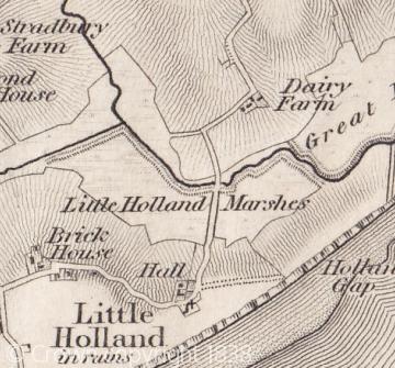
When the reclamation works were considered advanced sufficiently, a causeway was built across the reclaimed land and a new bridge, named Little Holland bridge, was built over the brook. The date of the bridge is uncertain, but it was first recorded in 1727. The bridge was locally significant for it was the first time that a direct road communication existed between the settlements of Little Holland and Great Holland on the two sides of the old estuary. Chapman and Andre's map of Essex in 1777 shows the nature of the land half a century after the bridge was first built. A road led from Little Holland Hall into the marhses and then crossed the Holland brook by the new bridge before travelling northwards through the marshes and up the valley side towards Great Holland.
The approach road to the bridge through the marshes in 1777 was depicted as a series of dashes indicating that the route was rather impermanet or uncertain and liable to flood. Chapman and Andre often depicted roads in this way when they crossed common land or where routes were poorly demarcated; another example is their map of the route through the marshes east of Fan bridge. The present Holland bridge appears to date from the early 20th century and until rceent years it had a metal sign indicating where the Great and Little Holland parish boundaries met.
Sources:
J. Chapman and P. Andre, A Map of the County of Essex (1777).
Norden's Map of Essex (1594).
Ordnance Survey Map, 1" (1838).
Essex Record Office (ERO), D/ST 20 (Map of part of TendrinG level, 1783).
Tednring Levels Commissioners' Map (early 20th century; in private ownership).
Content derived from research undertaken as part of the Victoria County History project
