Rice bridge on Holland River
Rice bridge is the earliest recorded crossing point on the river now known as the Holland Brook, and one of the furthest inland. It was in existence by 1319 when an Agnes de Risbregge (Agnes of Rice Bridge) was recorded in a taxation return for Little Clacton. Her name probably meant that she lived at or near the bridge. The bridge also gave its name to the surrounding land as an estate called Risbridge or Rosebridge was recorded in the later 16th century.
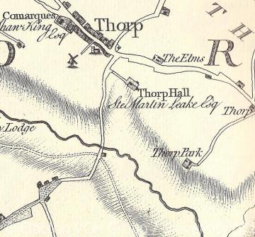
The bridge was built on a route that was probably locally important in the Middle Ages. Not ony did it connect the two parishes of Thorpe-le-Soken and Little Clacton, but also the manors on either side of the river that were owned by the bishop pf London and his cathedral church of St Paul's. In the Domesday Book of 1086 the bishop held the manor of Clacton (comprising both Great Clacton and Little Clacton) while all of Thorpe-le-Soken, Kirby-le-Soken and Walton-le-Soken were held by the Dean and Chapter of St Paul's (the cathderal clergy). By 1127 on one side of the bridge lay Little Clacton park, a deerpark owned by the bishop, while on the other side lay Thope park, a deerpark owned by the Dean and Chapter. The road over Rice bridge therefore connected the two church estates and their hunting parks. Possiby the huntsmen ranged across both parks quite freely, otherwise the deer could have swum across the river to safety!
The name Rice bridge is itself very informative, as it probably originates in the Old English words 'hris' (meaning brushwood) and 'brycg' (meaning bridge or causeway). The crossing may therefore have started out as a timber bridge or causeway and it probably continued in that form for many centuries. In 1612 the tenants of Thorpe Park and Clacton Park were ordered to 'make' the bridge (perhaps from timber available in the deer parks), and it was still described as a wooden footbridge in 1783. County maps from 1594 and 1603 show a main road from Little Clacton and Weeley towards Thorpe, Kirby and Walton that crossed the Holland River at what must be Rice bridge, although it was not named. A survey of the Holland Levels by the Tendring Levels Commissioenrs in 1703 named Rice bridge, and many maps from the 18th century such as that by Chapman and Andre in 1777 show the same route. The present brick built Rice bridge dates from the early 20th century.
Sources:
P.H. Reaney, The Place-Names of Essex (Cambridge, 1935), p. 336.
P. Morant, The History and Antiquities of the County of Essex (1768), Volume II, p. 475.
M. Gibbs (ed), The Early Charters of St Paul's (Camden Society, 3rd series, lviii, 1939), no. 60.
J. Chapman and P. Andre, A Map of the County of Essex (1777),
Norden's Map of Essex (1594)
London Metropolitan Archive, Guildhall Library, MS. 25416/3; MS. 9531/6, f.192v.
Essex Record Office (ERO), Q/SR 199/79, 154, 155 (Quarter Sessions).
ERO, D/DHw E14 (A true survey of ye Levll or Flatts ... several parcells of land endamaged at or near Gun-Fleet Haven, 1703).
ERO, D/ST 20 (Map of part of Tendring Level, 1783).
Content derived from research undertaken as part of the Victoria County History project
