Fan bridge on Holland River
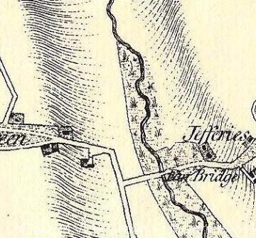
Fan bridge is the second earliest rcorded crossing point on the river now known as Holland Brook (formerly Holland River). Further downstream than Rice Bridge, the river valley here was broader in character and more liable to flood. Fan Bridge (often spelt 'Fann' or 'Fenn') was first recorded in 1509 and it was also depicted on Norden's map of 1594; its name is likely to mean fen or marsh. The present flood plain of the Holland Brook probably indicates the width of the river in medieval times, and at Fan bridge it is nearly one tenth of a mile across. The site of the bridgemust therefore have been approached by a causeway through the marsh before a bridge spanned the main channel of the Holland Brook. Indeed, the original route may have been on a different alignment and changed when the bridge was built, which might explain the curious dog-leg in the approach road from Little Clacton (see map).
The Chapman and Andre map of 1777 shows that the fens still existed all around the bridge at that date. The same map reveals that the approach road through the marsh to the west of the bridge (Little Clacton side) was relatively short, but that on the other (Great Holland side) it was longer and shown as a series of dashes indicating that the route was impermanent and liable to flood. Chapman and Andre often depicted roads in this way when they crossed common land where routes were poorly demarcated. A good example is the track through the middle of Cooks Green in Little Clacton, to the west of Fan Bridge. The name Fanbridge Common was recorded between about 1600 and 1800, revealing that the fens next to the bridge continued to be used for common grazing at certain times of the year.
The probable later date of Fan Bridge, compared to Rice Bridge, may have several explanations. This was certainly a more difficult and marshy location for a bridge, and in earlier centuries when the Gunfleet estuary was more open to the sea it may have been an impractical location. In addition, Fan Bridge was located on a more minor local road linking the parishes of Great Holland and Little Clacton. On the west side between Clacton village and the bridge lay the hamlet of Cooks Geeen, while on the east between Great Holland village and the bridge lay Great Holland Common (or Jeffries Common). These greenside settlements were minot and traffic between them was probably not extensive; in the Middle Ages and later Little Clacton and Great Holland manors were also in different ownership.
In later centuries the bridge was apparently maintained by the parishes of Little Clacton and Great Holland. In 1776 the Little Clacton parish surveyors (the parish officials in charge of highways) painted posts at the bridge, and in 1795 they built a new bridge of timber and brick (although it was not named). According to a survey of the Tendring Levels in 1783 the bridge was constructed of brick. In 1808 Great Holland's parish surveyors accounted for the demolition of the old bridge and the erection of a replacement. In 1821 the Little Clacton surveyors carried out work on 'Holland Bridge', presumably meaning Fan Bridge (rather than the true Holland Bridge between Little Holland and Great Holland). It is not known how long the 19th-century brick bridge lasted. The present brick bridge appears to date from the early 20th century.
Sources:
P.H. Reaney, The Place-Names of Essex (Cambridge, 1935).
J. Chapman and P. Andre, A Map of the County of Essex (1777)
Norden's Map of Essex (1594)
Essex Record Office (ERO), D/DHw E14 (A true survey of ye Levell or Flatts .... several parcells of land endamaged by a breach at or near Gun-Fleet Haven, 1703).
ERO, D/ST 19 (Map of part of TendringLevel, 1783).
ERO, D/P 80/21/1, 2 (Little Clacton Parish Surveyors' Accounts, 1769-1807, 1813-35).
ERO, D/P 396/21/1 (Great Holland Paroish Surveyors' Accounts, 1804-40).
Content derived from research undertaken as part of the Victoria County History project
