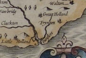
The Gunfleet Estuary in 1610
Period:
Medieval (AD410-1485), Early Modern (1485-1750), Tudor (1485-1603), Elizabethan (1558-1603), Stuart (1603-1714)Copyright:
Reproduced by courtesy Essex Record OfficeImage Caption:
The Gunfleet Estuary shown on John Speed's Map of Essex (1610). The open mouth to the sea is clearly shown between Little Holland and Frinton.