Recreation of the landscape of Gnosall in the mid-14th century
Gnosall, a Minster Church?
Gnosall was probably an important ecclesiastical centre by the 10th or 11th century and may have been the site of a minster, a type of church that pre-dated the formation of parishes and parish churches. A minster was served by a community of priests who travelled far and wide preaching across a territory much larger than that of the later parish. The minster church and the community’s domestic dwellings, workshops, kitchen gardens and space for stock were enclosed within a precinct bounded by a bank and ditch, often curvilinear in outline.
Minster churches are often difficult to identify because the physical evidence has usually been completely lost, as is the case at Gnosall; however, there are a number of clues. Domesday Book states that, in 1086 , a substantial amount of land in Gnosall was held by nine priests. The church also appears to have enjoyed royal patronage at this time.
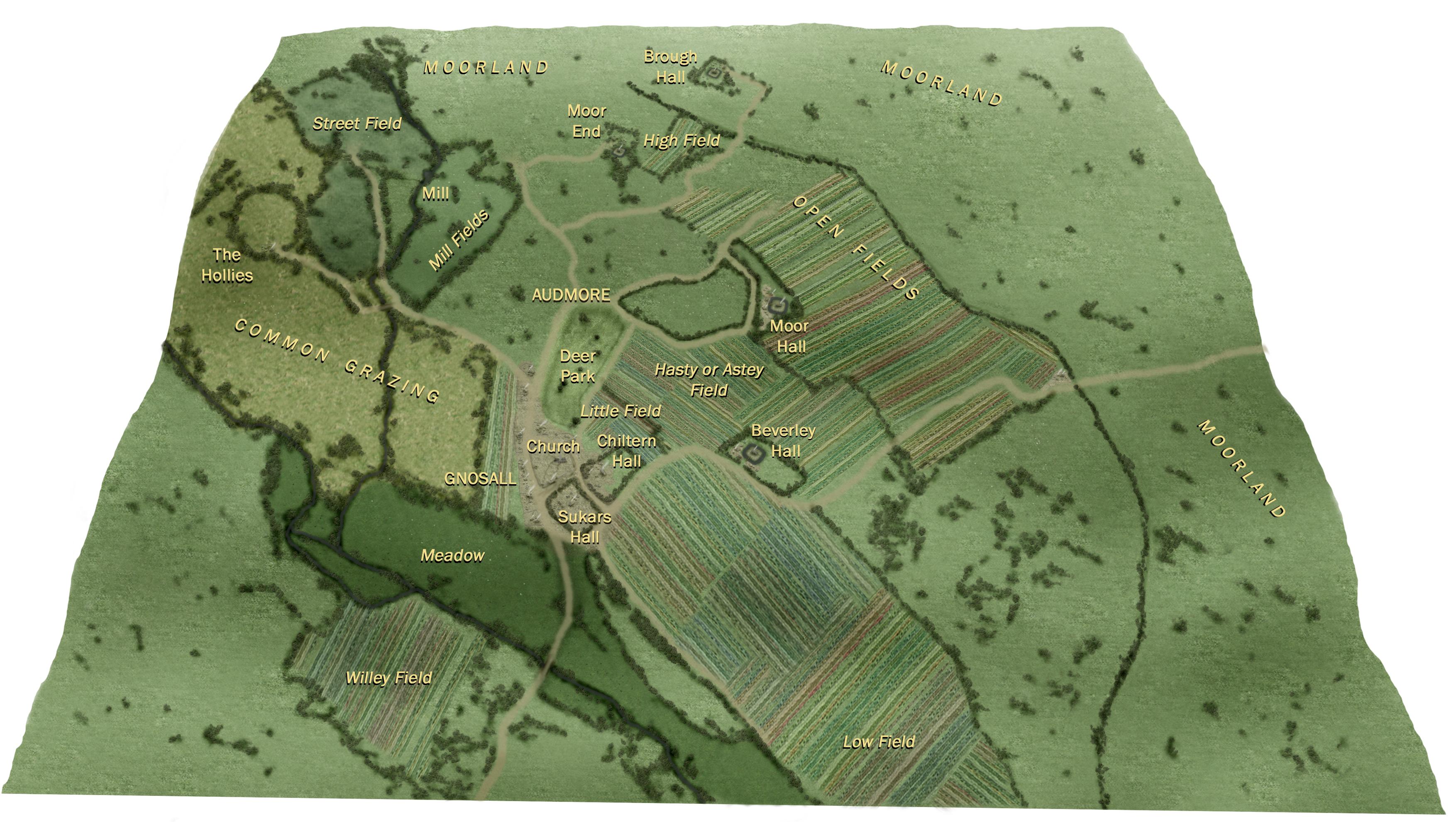
There may have been at least five open fields: Willeyfield, Highfield, Lowfield, Littlefield and the Hasty or Astey. These were used for growing crops on strips allocated to individual households. The Town Meadow lay along the wetter land near the Doley and Hollies brooks as they pass near the village. Cattle and sheep would be grazed here and hay cut each summer.
Gnosall manor was unusual in that it was divided into four prebendal manors known as Beverleyhall, Chilternhall, Moorhall and Sukarshall and there may have been manor houses for each of these. Manor documents from the 16th and 17th centuries indicate that only parts of buildings remained for Beverleyhall and Moorhall. Areas of heath and waste can be identified at Gnosall Heath, Doley Common and Hollies Common. These would have been held by the lord of the manor but his tenants would have common rights there to graze animals, cut turf/peat and gather vegetation such as bracken, heather or rushes. Tenants tended to try and encroach on these areas by enclosing pieces of ground and building cottages. There is much evidence of this at Gnosall Heath and on the borders of the two commons.
Gnosall, like other known minster churches, is unusually substantial for a parish church and stands close to a main communication route. In addition, the site on which the church stands is enclosed by a circuit of roads that may follow the line of a possible precinct boundary (see map). Further, an area lying to the south of the church was recorded as Seukesworth in 1369 AD; the second element of which (worth) means ‘an enclosure’. There are other examples of lost boundaries being perpetuated by modern road patterns, including at Hanbury in east Staffordshire where a similar enclosure is associated with a monastic community founded by St. Werburh in the 7th century.