Basingstoke Enclosure
Basingstoke was enclosed by parliamentary enclosure in 1788. Basingstoke is a large parish of over 1,500 ha. The underlying rock is chalk which falls gently to the valley of the River Loddon which runs towards the Thames beyond the north east of the parish. This small river was the source of water for the small town, which only occupied 4% of the parish in 1836 (see figure 1) meaning that farming was a major occupation in to the nineteenth century.
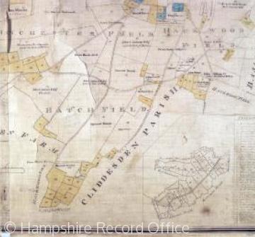
In 1256 Henry III granted a charter which enabled the men of the market town to become in time a self-governing community. (1) Through their two courts the citizens protected their open field system from encroachment and dissolution until the 1788 Enclosure Act. The 1762 map shows 6 open fields covering 80% of the parish with the Down as common grazing. Figure 2 shows Hatch Field with some licensed enclosures at the edges and many strips combined together by exchange but some individual strips remaining. The largest landowner, the Duke of Bolton, had 12 tenant farms covering over 240 ha but these were divided into 600 separate strips of under 0.5 ha each spread over the six fields. There were only 62 owners of land and 36 of them owned less than 0.5 ha. (2)
The pressure for enclosure came from the larger landowners and their main motive was the creation of compact farms which would yield higher rents. (3) Six of the largest owners or 10% of the total owned 62% of the land and they were able to enlist the support of enough medium sized landowners to ensure that over 75% supported the bill. (4) Half the owners only controlled 3% of the area. The majority of the townspeople supported the Corporation and Merton College in opposing the bill but to no avail. Of a population of c. 2000 only 20 residents owned land and no more than 50 occupied land. (5)
The townspeople’s common rights were adversely affected. They lost grazing rights on Basingstoke Down (251 ha remote from the town) and were compensated by a common of 43 ha adjacent to the town. Stinting rights were based on the 1785/6 Poors Rate and 1288 ‘legs’ were allocated 500 of which were allocated to 250 cottages with 2 legs each. Arthur Young in 1806 adversely commented on the effect on the poor people of Basingstoke and, unsuccessfully, advocated double allocations to all with low rentals to give minimum allotments of 22 – 44 perches enough for a good garden for those who could not afford stock.
1. STOKES, E (2008) The Making of Basingstoke, Basingstoke p 37
2. SPRUCE, D (1976) Basingstoke 1780 – 1860: Aspects of the Development of a North East Hampshire Market Town Unpub M.Sc dissertation Univ London. Copy in Basingstoke library p 31
3. JONES, E.L. (1960) ‘Eighteenth Century Changes in Hampshire Chalkland Farming’ Agric. Hist. Rev VIII p 9
SPRUCE op.cit. p 27
4. Ibid. p 33
5. YOUNG, A (ed) (1806) ‘Annals of Agriculture’ Vol XLIV (London) p 53
Content derived during research for the new VCH Hampshire volume, Basingstoke and its surroundings.


