The borough of Sunderland, c.1600-1719
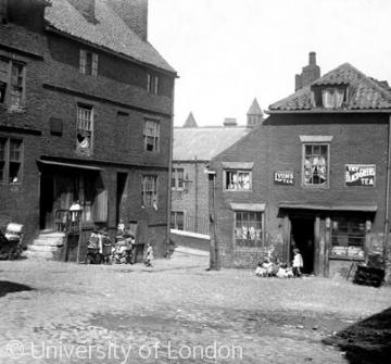
The town plan of Sunderland was determined by the layout of its medieval burgages. The accompanying photographs illustrate the long survival of the old borough plan. The burgesses had houses with small frontages on to the high street, but stretching far back to accommodate workshops, gardens and other necessities. As pressure grew on this land, with rapid expansion of the port from the 17th century, infilling and overcrowding were the result. Many of the "lanes" on early maps were little more than alley ways or passages under buildings, but they mark boundaries that had survived for many centuries.
Content generated during research for two paperback books 'Sunderland and its Origins: Monks to Mariners' (ISBN 13 : 9781860774799) and 'Sunderland: Building a City' (ISBN 13 : 978-1-86077-547-5 ) for the England's Past for Everyone series


