The Tendring Level (Holland Haven)
Responsibility for sea defence and drainage in coastal regions since the early thirteenth century had been allocated to ad hoc Commissions of walls and ditches (de walliis et fossatiis) appointed by the Crown. The commissioners were officers who had powers to enforce local communal responsibilities for the maintenance of sea walls, banks and drains, and thus attempt to prevent flooding and the inroads of the sea. They could make local by-laws and raise rates to ensure the essential work was undertaken.
Such commissioners for Tendring Hundred (equivalent to the modern Tendring district) were first recorded about 1450, when the abbot of St Osyth, John Godmanston, esq., John Green and Robert Tanfield and others were appointed. The powers of such royal Commissions was consolidated by Statute in 1531 in A General Act concerning Commissions of Sewers. This was enacted 'considering daily great damages and losses which have happened in many and diverse parts ... by reason of the outrageous flowing surges and course of the sea in and upon marsh grounds and other low places'. Under the 1531 At the Commissions initially only lasted three years, but another Commissions of Sewers Act of 1571 later extended the term to ten years.
It is possible that the Tendring commissioners met infrequently for information about the 15th and 16th centuries is scant, and the extent of the sea defences around the Gunfleet estuary and on the coastline of Great Holland, Little Holland and Frinton remains unknown. A reference to 'le level de Gunfletehaven' in 1542 may indicate that some drainage activity had taken place, for the word 'level' was often used of partly reclaimed marshlands of the type protected by the activities of commissioners. Other examples of the use of the word are the Somerset Levels and the Gwent Levels of south-east Wales. A document concerning poaching at Little Holland in 1609 referred to 'a drowned land called the Flatts', and the same term was used as an alternative for the Tendring Level in 1703.
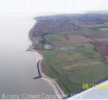
It would seem that the gradual silting up of the Gunfleet estuary and the Holland Brook or River that fed it necessitated a response from the commissioners, probabaly stimulated by those whose livelihood was being affected by the flooding and perhaps the loss of trading opportunities. The response was a plan to make a sea wall across the estuary between Little Holland and Frinton, and thus reclaim by drainage the former estuary. It is not known precisely when the sea wall was first constructed, but it appears to have been sometime in the 17th century. A survey of the Tendring Level after the Great Storm of 1703 mentioned a 'breach' that had been made, suggesting that the sea wall existed by that date.
A sluice was included in the new wall which could be opned at low tide to allow the river watre to escape, the sluice gate then being closed to prevent th rising tide from entering and flooding the newly won marshes. The original sluice was at Sandy Point near Frinton which seems to have been the natural outfall of the river water from the Holland Brook, although it was later moved east to the site of the present sluice at Holland Haven. As a result many hundreds of acres of land were reclaimed in the parishes of Great Holland, Little Holland, Frinton, Great Clacton, Little Clacton and Thorpe-le-Soken.
Sources:
K. Walker, 'The battle of the Clacton peninsula. Man versus the sea', Essex Review, Volume LXIV (1955), pp.103-11.
P.H. Reaney, The Place-Names of Essex (1935), p. 17.
J. Yelloly Watson, The Tendring Hundred in the Olden Time (1877), p. 70-1.
Essex Record Office (ERO), D/DHw E14: A true survey of ye Levell or Flatts (1703).
ERO, Q/SR 189/25: Quarter Sessions, pocahing case, 1609.
The National Archives, Catalogue explanations under references C191, C225, C226.
