Reclaiming the Estuary
The creeks and marshes along the Essex coast contain large areas of salt marsh. These were used as land to graze sheep in summer, but were often flooded and inaccessible in winter. However, the land was more valuable if it could be reclaimed from the sea, drained and protected from the salt water by a sea wall which is what happened in the Gunfleet estuary.
The mouth of the estuary was probably protected in earlier centuries by a headland (a Ness) at Little Holland Hall and another at Frinton, but these were eroded to create the straighter coastline of today. It is probable that some land reclamation was already happening in the Medieval and Tudor periods and natural processes such as silting and longshore drift continued to change the size and shape of the estuary.
The Tendring Level Commissioners, a public body recruited from local landowners, decided to construct a sea wall in the 17th century. This meant that hundreds of acres of land was reclaimed in the parishes of Great Holland, Little Holland, Frinton, Great Clacton, Little Clacton and Thorpe-le-Soken. A sluice was built in the wall to allow the river to drain into the sea. By preventing salt water entering the marshes the land in the estuary would be improved for agricultural use.
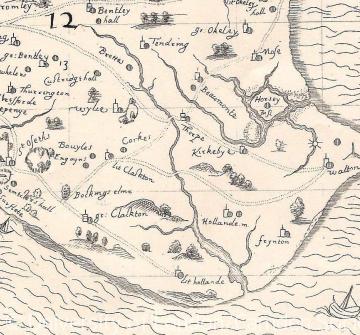
This changing landscape had an effect on local land use. Maps of 1594 and 1603 indicate that there was no route at that time across the Gunfleet estuary which still formed a major barrier to land communications along the coast. As a result, there was probably much communication in small boats across the Gunfleet estuary and along the coast in the sheltered waters of the Gunfleet Channel.
Inland, Rice Bridge is the earliest recorded crossing point of the Holland River and was in existence by 1319. It was probably a timber bridge or causeway at this point and was described as a wooden footbridge in 1783. The bridge connected the two parishes of Thorpe-le-Soken and Little Clacton. The present brick built Rice bridge dates from the early 20th century.
Fan Bridge is the second recorded crossing and is further downstream than Rice Bridge where the river was wider and the land more liable to flood. This was certainly a more difficult and marshy location for a bridge, as the name Fan or Fen suggests, and in earlier centuries when the Gunfleet estuary was more open to the sea it may have been an impractical location. The crossing is first recorded in 1509 and is shown on the 1777 map with a dashed line to indicate the marshy terrain. New bridges were built in the 18th and 19th centuries with the present brick bridge appearing to date from the early 20th century.
Holland Bridge is the most recent bridge to cross the Holland River, and is the furthest downstream. When the reclamation works were considered sufficiently advanced, a causeway was built across the reclaimed land and the new bridge, named Little Holland Bridge, was built, although on the 1777 map the approach road through the marshes is depicted as a series of dashes to mean that the route was rather impermanent or uncertain and liable to flood. The date of the bridge is uncertain, but it had probably not been built long when it was first recorded in the 1720s. This bridge was locally significant as it was the first time that a direct road communication existed between Little Holland and Great Holland on the two sides of the old estuary.
You can explore Reclaiming the Estuary using the suggested activities and assets below.
How has the landscape changed?
Spot the difference in the landscape using maps 1594, 1777, 1838. You can play a game of spot the difference by using two maps and challenging a partner to find as many differences between them as possible. At the end make a list of what has changed and what has stayed the same. You could also play this as a question and answer activity, with players trying to work out their partner’s chosen map or map feature by asking and answering questions.
Consider the effects of natural processes
Use maps 1594, 1777, 1838 to overlay and trace the physical features of the landscape creating a new map showing how the landscape has changed over time. Use your knowledge of natural processes (long shore drift, silting, and erosion) to label the new map showing how each has had an impact on the landscape. Extend this activity by adding in labels for human features (river crossings, roads). Use the new map to explain the consequences of the physical changes for local people in terms of industry, agriculture, and communications.
Building bridges
Your team are in charge of building a bridge at Holland Haven in 1594, 1777 or 1838. It could be a new bridge to cross the river or a replacement for an existing bridge. The answers to these suggested questions might help you think about where your bridge should be and what it might be built from.
Why do you need a bridge? (think about people, jobs, travel)
Where is a good place for the bridge? (think about how wide the river is, how marshy the land is)
What will the bridge look like? (think about materials, coast and strength)
Have a competition to design and build a river crossing for each of the dates. At the bridge opening each team will need to explain their choices of location, design and materials.
Content derived from research undertaken as part of the Victoria County History project


