Navigating the Wear Estuary
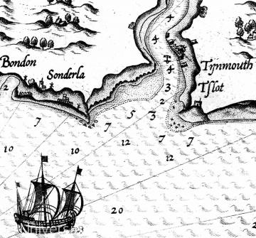
As the port developed its overseas trade, Sunderland began to appear on sea charts and navigational guides. The settlement of Bishopwearmouth and its good anchorage featured in later Dutch atlases, published in 1637 and 1670.
The most complete navigational survey of the 17th century was by Capt. Greenville Collins, hydrographer to Charles II. Collins charted the British coast between 1681 and 1688. His resulting work, Great Britain's Coasting Pilot, being a New Survey of the Sea Coast, remained in print for decades after its first publication in 1693.
Content generated during research for two paperback books 'Sunderland and its Origins: Monks to Mariners' (ISBN 13 : 9781860774799) and 'Sunderland: Building a City' (ISBN 13 : 978-1-86077-547-5 ) for the England's Past for Everyone series


