Monkwearmouth: a medieval village uncovered
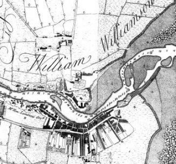
There had been little change in the layout of medieval Monkwearmouth when this map was published in 1737. The name of the main landowner, Sir William Williamson, here divides the settlements of Monkwearmouth and Monkwearmouth Shore.
The southernmost, the Shore township, covered the same area as the old cell, or monastic estate, including of course the church of St Peter and the monastery buildings, converted into Monkwearmouth hall.
To the north of Sir William's name lies the old village of Monkwearmouth, roughly an inverted triangle with roads leading north towards Newcastle and South Shields. The large size of village green, and the random pattern of houses, points to this having been a very old settlement - perhaps pre-conquest. Historically, as service settlement of the Anglo-Saxon monastery, this is a very significant site.
Monkwearmouth today is hardly the most quaint or picturesque part of Sunderland. Scratch the surface, though, and remains of a medieval village are waiting to be exposed.
Content generated during research for two paperback books 'Sunderland and its Origins: Monks to Mariners' (ISBN 13 : 9781860774799) and 'Sunderland: Building a City' (ISBN 13 : 978-1-86077-547-5 ) for the England's Past for Everyone series


