An introduction to Holland Haven
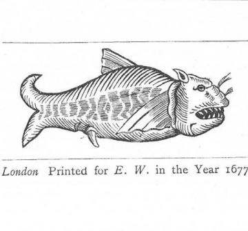
Today, Holland Haven is the place where the Holland River (now the Holland Brook) once ran out into the North Sea between Clacton and Frinton in Essex. This estuary was called the Gunfleet and it was once wide enough for boats to sail through it and in 1677 for a whale to become stranded there. Towards the end of the 17th century a sea wall was built across the mouth of the estuary, the land behind the wall was reclaimed from the sea and converted to marshland pastures.
Geographically, the Essex coastline is characterised by a series of creeks, inlets and estuaries which in the past have allowed access for small boats to sail inland. When the Gunfleet estuary was open to the North Sea, small boats may have been able to sail up river as far as Thorpe-le-Soken. Small wharves and landing places were built along the banks of Holland River allowing crops grown on nearby farms and other local produce to be loaded easily onto boats and carried along the river, out to sea, into the Thames estuary and into London.
Remote and out of the way landing places could also be used to avoid customs control and the isolated marshes at Holland were notorious in the past for smugglers even after the estuary was reclaimed.
We can get an idea of what it would have been like in the Gunfleet estuary by looking at nearby Beaumont Quay on Hamford Water which was used as a landing place for boats from the Middle Ages to the 1930s. From here barges were loaded with produce such as corn, hay, cheese and timber, and brought return cargoes, mainly building materials or soil improvers such as manure and chalk from London, Kent and Essex.
Another feature in this landscape would have been tide mills, different to water mills or windmills as they use the ebb and flow of the tides to power the waterwheel. The Essex coastline was dotted with this ancient type of mill with sites identified at nearby Thorrington, St Osyth and Walton-on-the-Naze. The work of tide mills was often supplemented by a nearby windmill such as at Thorrington and Walton-on-the-Naze.
We know that alongside agriculture, the copperas industry was also important locally in the 17th and 18th centuries. Copperas stones (which were actually iron pyrites) were washed out of the London Clay cliffs onto the shore and converted to copperas (green vitriol) at factories known as Copperas Houses. Copperas was used for various purposes such as dyes and inks. The stones were collected by local people all along the coast from Clacton, Frinton and Walton, and were also dredged up from the Copperas Bank off the coast.
The reclaimed estuary is now used for leisure pursuits, including the Holland Haven country park and Frinton Golf Links.
You can explore An introduction to Holland Haven using the suggested activities and assets below.
Use maps to introduce your study
Use a modern map to locate the Holland Haven area by first viewing Europe, UK, East Anglia, the Essex coastline (naming the North Sea, London and the Thames estuary), and finally Clacton, Walton and Frinton. Use these key places to locate the course of the Holland Brook and notice the marshes, follow the length of the Brook - it looks a bit like a ladder. Find other places of interest such as your school, local beaches and houses.
Use one or more of the maps Norden 1594, Chapman and André 1777 and OS 1838 to find out what was it like here in the past. Compare the historic map with your modern map. You can use the map showing land liable to flood on the Holland Marshes as an indication of the size of the former estuary. These are some suggestions to help you explore what is the same and different:
Look for local place names and spellings. It might help to read them out loud.
Follow the shape of the roads
Follow the shape of the coastline and waterways
Locate crossings over the river and if you are using more than one map check if they are on each one. What does this tell us about when they were built?
Can you see any buildings? What are they?
Extend this activity by tracing or overlaying the maps chronologically to locate, describe and label the changes that have happened in the landscape including the shape of the estuary.
What was life like here for people in the past?
Use images “Copperas pickers” on the shoreline at Harwich, photos Thorrington Mill (1929), Beaumont Quay (1960) and documents ‘A monstrous whale’, Poaching on Holland Marshes and Possible landing places on the Gunfleet Estuary and choose one or more maps.
Think about what you would like to know and group your questions under headings (for example, work, food, events). Look at each source for the information it gives you to answer your questions. Move on to another source and add in more information. Remember that there are additional assets for you to use on other parts of the VCH Explore site (link to home?).
Go on a fieldtrip
Use a modern map and historic map together to plan a route for a walk or place to visit. Aim to take in as many of the landmarks and features identified in the previous activities as possible. Take photos or make sketches and use these to label a copy of the map. Add labels with the answers from your previous activities, and explain the connections between past and present human and physical features.
Content derived from research undertaken as part of the Victoria County History project


