Holland Brook
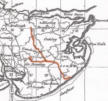
The Holland Brook, sometimes called the Holland River, has been rather overlooked as an important landscape feature of Tendring Hundred (the older name for Tendring district). Even the original name of the watercourse is uncertain, although as the Holland Brook fed into the Gunfleet estuary that may record the original name of the river - the Gunfleet. The names Gunfleet Haven and Holland Haven both seem to refer to the original estuary that was later permanently reclaimed from the sea by the Tendring Levels Commissioners in the 17th and 18th centuries.
The brook was regarded as important enough for its course to be described in versions of Holinshed's Chronicles dating from 1577 and 1587: "Betwixt the Naze also and the mouth of the Colne, is another Ryll which riseth at Little Bentley, and thence goeth to Tendryng thorpe, thorow Clacten parke by great Holland, and east of little Holland into the deepe sea". The accurate description draws attention to the length of the watercoruse or 'rill' from its source near Little Bentley and Little Bromley down to the sea at Little Holland, which virtually divided Tendring Hundred in half. Several features are worthy of note:
First, the original Gunfleet estuary and the Holland Brook and its valley probably provided an important access route from the coast into the interior of Tendring Hundred both in prehistoric and later periods. There is considerable evidence from cropmarks for early settlement around the upper reaches of the brook in Tendring and neighbouring parishes. The brook may also have had an influence upon the later Anglo-Saxon and medieval patterns of settlement. It may, for example, be no coincidence that the brook leads to the parish of Tendring, which was the central place of the Hundred (the Hundred assembly met on Tendring Heath), and which name is probaby derived from a place-name in Germany transferred to this location by Anglo-Saxon migrants.
Second, the Holland Brook and the Gunfleet estuary later provided a considerable barrier to east-west road communications. A number of bridges were therefore eventually established, presumably starting furthest inland where the watercourse could be more easily bridged. That at Rice bridge, between Thorpe-le-Soken and Little Clacton, seems to have been present by the 14th century. Further downstream that at Fan bridge, between Great Holland and Little Clacton, was first recorded in 1509, and that at Holland bridge, between Great and Little Holland, in 1727 (after the former estuary had been reclaimed).
Third, the Holland brook and Gunfleet estuary were fed by a number of smaller streams in the parishes along their route, and the system effectively drained much of the centre of Tendring Hundred and many thousands of acres of farmland. Some of the tributary streams were quite small, but others like Picker's Ditch leading west from the Gunfleet towards Great Clacton were quite substantial. The potential for flooding was therefore very large, and after the Gunfleet or Holland Haven was reclaimed as marshland pasture by the Tendring Levels Commissioners they had to work hard expending money and enforcing maintenance upon local landowners to keep the channels clear so as to prevent major flooding incidents. Even in winter today the course of the brook and the old estuary is often marked by the flooded marshlands.
Sources:
P.H. Reaney, The Place-Names of Essex (Cambridge, 1935), 17, 325, 351-2.
Norden's Map of Essex (1594)
Map of Tendring Hundred from P. Morant, The History and Antiquities of the County of Essex, I (1768).
Holinshed's Chronicles: http://www.english.ox.ac.uk/holinshed/
Essex Explore Asset under this heading: Map of land liable to flood.
See other Explore Items on Rice bridge; Fan bridge; Holland bridge.
Content derived from research undertaken as part of the Victoria County History project
Content derived from research undertaken as part of the Victoria County History project
Content derived from research undertaken as part of the Victoria County History project


