Beaumont Quay
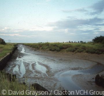
The historic site known as Beaumont Quay is an important survival showing the nature of the small quays and wharves that were once very common and busy along the Essex coast. It is located right at the end of the tidal Landermere Creek, on the northern bank, which provided access for boats to Hamford Water and then to the North sea. The site is now owned by Essex County Council and is a scheduled ancient monument.
Archaeological material has revealed settlement in this area in the Iron-Age, Roman and early medieval periods, as well as evidence for salt-making. There was probably also a landing place or wharf which served the large and valuable medieval manor of Beaumont Hall. In the Middle Age the overlords of the manor were the de Vere family, the earls of Oxford, while the local lords (manorial tenants) were the Berners family. In 1577 a list of all the ports, havens, creeks and landing places on the Essex coast recorded a creek, three landing places and four customs deputies at Thorpe-le-Soken and Beaumont. One of those landling places is likely to have been near Beaumont Quay and another one at Landermere Wharf in Thorpe. Such landing places were used to export agricultural produce such as corn, hay, and cheese from local farms like Beaumont Hall to London.
In the 16th century the manor passed to the crown, and in 1551 King Edward VI granted it to Sir Thomas Darcy of St Osyth. Ownership of the estate then descended in the Darcy family, who became the earls Rivers, until it passed, probably by sale, to Francis North, 2nd Baron Guildford (d. 1729). Shortly before he died Francis sold the estate and the quay to the governors of Guy's Hosptal, London. The governors were investing heavily in Essex property having been left the enormous sum of £220,000 (about £28 million in today's money) by Thomas Guy as an endowment for their institution. In 1727 they commissioned a survey of Beaumont Hall prior to their purchase, which not only recommended it as a very good buy, but noted that there were two "very convenient landing places for bringing chalk rubbish from Kent and carrying of corn or any other thing off to London". This neatly describes the two-way traffic to London, with corn being taken to market and soil improvers being brought back as the return cargo - in this case chalk but just as often horse manure and 'night soil'.
The 1727 survey had also noted that the two landing places could only be used at very high tides, probably because the natural water channel of the Creek was rather shallow and emptied too quickly on the ebb. By the early 19th century agricultural production and yields had improved and the governors decided to invest in creating a more efficient quay. In 1831 London bridge was demolished and replaced, and Thomas Guy's Hospital acquired some of the old stone blocks which it transported to Beaumont to build a new quay in the following year. The quay was about 80 metres long, partly of stone (unmortared) and partly of timber. In addition, the governors paid for the digging of a new channel or canal called Beaumont Cut, two metres deep and about 1km long which linked the quay to deeper water in Hamford Water. A basin at the quay allowed barges or other vessels to turn around, and in 1848 it was described as navigable for vessels up to 70 tons.
The heyday of the quay was in the mid and later 19th century, when it saw a busy trade. There were buildings at the quay by 1838, probably including an arcaded brick warehouse that survived until the later 20th century. The tenant of Beaumont Hall, Mr Sewell, also built a kiln besides the quay, for the production of lime for agricultural purposes. The kiln ceased production in the mid 1920s, and the last trading barge used the quay in the 1930s. A 42-ton barge called the Rose, built in 1880, was towed to the basin in the early 1960s for conversion to a house boat, but later became derelict and damaged in a fire. Its wreck is still visible, slowly subsiding into the mud. Some of the buildings at the quay were demolished soon afterwards, but one store house has survived as does the kiln.
Sources:
J. Moore, 'Beaumont Quay', Colchester Archaeological Group Bulletin, 54 (2014), pp.8-12.
D. Buckley, 'Lost and Found: The Archaeology of the Essex Coast', in A. Aberg and C. Lewis (eds), The Rising Tide. Archaeology and Coastal Landscapes (Oxbow Books, 2000), pp. 5-16 (pp.10-11).
W. White's, History, Gazetteer and Directory of the County of Essex (1848).
Essex Record Office, D/DGh E1. Survey, 1727.
The National Archives, SP12/117 (31), Oct. 1577. John Lord Darcy of Chiche and others. List of all ports, havens, creeks and landing places and list of deputies.
Ordnance Survey Map 1" (1838 edition).
Content derived from research undertaken as part of the Victoria County History project


