Barton's Pans
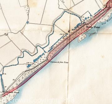
Barton's Pans lie immediately behind the line of the sea wall built by the Tendring Level Commissioners across the mouth of the Gunfleet estuary. They are located from just west of Chevaux de Frise point running east to Holland Gap towards Frinton. They take the form of rectangular pits, lagoons or pools, filled with water and overgrown with reeds. At least 24 separate pits were shown on an Ordnance Survey map of 1898, and although some have now disappeared or shrunk they are still a very prominent landscape feature. They are not modern because they were mentioned in the Tendring Level Commissioners Minute Book of 1782, as follows: "That part of the wall adjoining to a place called Bartons Pans wants strengthening and heightening and footing for near three hundred yards in length, and that water from the said pans ought to be drained at all times from out of the same."
The Commission's map of the Level from 1783 also marks the location of the Pans, while the Commissioners minutes from 1786 notes that the sea wall next to Barton's Pans was "by the violence of the sea becoming ruinous, defcetive and out of repair." The 'Pans' are also depicted on a military survey of Holland Marsh in 1805 (part of the defence planning aginst the threat of invasion by Napoleon Bonaparte's French army), being shown as lying between Chevaux de Frise Point and Sandy Point.
Hitherto the 'Pans' do not appear to have been studied, and their origin and purpose is shrouded in mystery. One hypothesis proposed is that material for the earliest sea walls was excavated from them. However, this explanation has not appeared fully convincing. Would suitable material have been available for excavation at the mouth of the old estuary? Also some of the 'Pans' depicted on maps also seem too regular in form (rectangular), and at the eastern and western ends do not precisely conform to the line of the sea wall. Other suggestions have been that they represent salt-pans (where salt was produced by heating or evaporation) or oyster-layings or tanks (where the young oyster brood were matured). However,no local documentary evidence has been found of either of these industries on such a large-scale as this site would imply. Also, before the sea wal, the 'Pans' would have lain on the open coast in the mouth of the Gunfleet estuary, probably not a suitable site for either salt or oyster production.
The explanation that currently seems most attractive is that the 'Pans' are evidence of the Copperas industry which we know was locally important in the 17th and 18th centuries. Copperas was the name for green vitriol that was manufactured from nodules of bisulphide of iron (otherwise known as pyrites) washed out of the London Clay cliffs onto the shore. It was used for various purposes such as dyes, fixatives and inks. Copperas stones were collected by the local poor people all along the coast from Clacton, Frinton and Walton, and also dredged up from the Copperas Bank off the coast. There were several methods of production, but in one system the Copperas stones were heaped into large open vats or pits full of water and exposed to the elements for a period of time (sometimes several years) before being removed to undergo various manufacturing processes at Coppers Houses, of which there were important local ones at Walton and Brightlingsea, and possibly another one at Frinton. Perhaps Barton's Pans were established for the Copperas industry after the sea wall was built towards the end of the 17th century?
Further evidence that may link Barton's Pans with the industry comes from the surviving Tokens with which the local poor - the "Copperas pickers" - were paid, and the names of the local landowners who issued them. Tokens survive that were issued by John Kirby at Walton dated 1736, and it seems probable that he was related to the Kirby family who through marriage obtained Great Holland Manor in the later 18th century. A map of 1777 indicates that a track led from Great Holland Hall directly to Barton's Pans. Copperas also appears to have been collected at Frinton from the mid 17th century onwards, and as early as 1637 the lord of the manor, Sir Harbottle Grimston, was involved in the industry. In 1746 the right to gather Copperas still belonged to Frinton manor, and the lessee of the manor named John Rice minted tokens to pay workers both at Frinton and at 'Minster' - either Minster in Thanet or Minster in Sheppey (both in Kent). John Rice's local involvement is particularly revealing as he may only have taken the lease of the manor to acquire its Copperas rights, as he is probably the same John Rice of Deptford (Kent) who was a member of one of the leading families involved with the industry in Kent and Essex.
Sources:
Essex Record Office (ERO), D/ST 2: Tendring Level Commission, Minute Book.
ERO, D/ST 17: Map of the Tendringlevel by W. Cole (1783).
ERO, T/A 15/2/2; ERO, D/DWv/T80; ERO D/UFw C9/23.
J. Chapman and P. Andre, Map of Essex (1777).
The National Archives, MPHH 1/548: Major Bryce's Survey of Holland Marsh, October 1805.
J.C. Shenstone, 'Copperas Industry', in W. Page and J.H. Round (eds), The Victoria Historyof the County of Essex, Vol. II (1907), pp. 411-13.
T. Allen, M. Cotterill and G. Pike, Copperas. An account of the Whitstable Works and the first industrial-scale chemical production in England (Canterbury Archaeological Trust, Occasional paper, No. 2, 2004), pp. 32, 37-8.

